Data Products
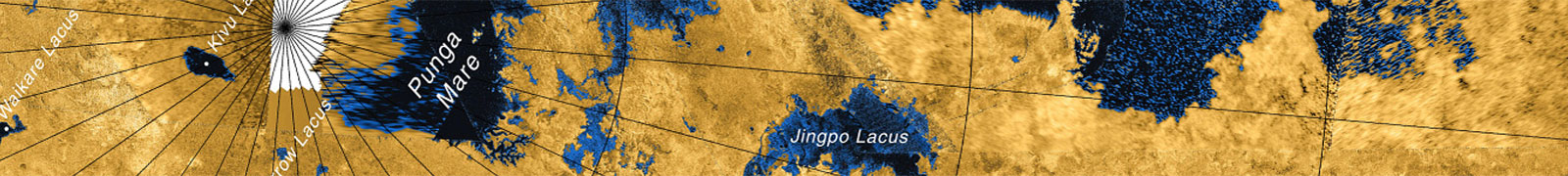
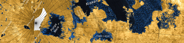
Titan SAR Data
https://doi.org/10.7298/knpx-8a85
Download: cassini_radar.tar.gz [92.3 GB]
Credit: USGS
Download: Titan_SAR_Swath_Outlines.zip [21 MB]
Credit: Léa Bonnefoy
Description: The full Cassini synthetic aperture radar (SAR) dataset of Titan, including swaths and mosaics, and shapefiles outlining the swaths.
Titan Polar Mapping
North Polar Region: https://doi.org/10.7298/smda-t742
South Polar Region: https://doi.org/10.7298/2bdt-p498
Download: titan_polar_mapping.zip [6.4 GB]
Credit: Samuel Birch (includes data from Birch et al., 2016)
Description: ArcGIS projects, along with corresponding SAR and topography data, used to create the geomorphologic map of Titan's polar terrains.
Topography of Titan
Download: dda_products_v2.rar [82.6 MB]
Description: Cassini delay/Doppler RADAR Altimeter Data Archive; broad-scale surface topography data for Saturn's largest moon Titan.
Titan SARtopo Derived Digital Topography Models
https://doi.org/10.7298/m4dv-gv95
Download: titan_topo.zip [27.5 MB]
Credit: Paul Corlies (Corlies et al., 2017)
Description: Updated topographic models of Titan, including all the available altimetry, SARtopo, and stereophotogrammetry topographic data sets available from the mission.
Titan Channel Map
Download: titan_channels.zip [1.1 MB]
Credit: Julia Miller (Miller et al., 2021)
Description: A shapefile (plus auxilary ArcGIS files) for global channel mapping on Titan, including certianty, stream order, width, and channel segment length.
Titan Equitorial SAR Mosaics
Quadrant 1: https://doi.org/10.7298/s709-7w42
Quadrant 2: https://doi.org/10.7298/4az4-gk54
Quadrant 3: https://doi.org/10.7298/vaaf-sy65
Quadrant 4: https://doi.org/10.7298/fz1q-ya32
Download: titan_equitorial_mosaics.zip [7.7 GB]
Credit: Samuel Birch
Description: SAR mosaics of Titan's equitorial regions, between latitudes 60S and 60N, divided into longitudinal quadrants.
Comet 67P Sediment Transport Map
Download: comet_67p.zip [520 MB]
Credit: Megan Barrington (Barrington et al., In Review)
Description: This dataset consists of a collection of 1) PNG files used as basemaps with and without latitude and longitude lines, 2) PNG files used as layers used for analysis, 3) projection files recording the georeferencing data for each co-registered images, 4) shapefiles annotating locations and types of changes in each image and 5) ArcMap projects for each region.