Titan's Lakes
Titan North/South Poles Globe Animation
Saturn’s moon Titan is the only extraterrestrial body currently known to support standing bodies of liquid on its surface and, along with Earth, is one of only two places in the solar system which currently have an active hydrologic cycle. Both Titan and Earth have rain, evaporation, erosion, standing bodies of liquid, and groundwater flow. Understanding methane flow on Titan teaches us about the development of Earth-like planets in both our own solar system as well as around other stars, and provides context for future discoveries in the field of extra solar planets. Results from Cassini have even led some scientists to believe that the lakes may represent a habitable environment in which an exotic form of life could have evolved. For these and other reasons, Titan remains a high priority target for future spacecraft missions.
I am interested in understanding the role of liquid methane in Titan’s hydrologic cycle. Particularly I study the interaction between subsurface, surface, and atmospheric methane and ethane reservoirs using data from Cassini RADAR instrument. Understanding methane flow is essential to a general understanding of Titan’s hydrologic system.The key questions I am interested in exploring with my research are:
- How does methane transport vary seasonally and geographically on Titan?
- What is the importance of subsurface transport, relative to atmospheric and surface properties, in Titan’s methane cycle?
- What are the differences and similarities between Titan and Earth’s hydrologic cycles, and how can we use aspects of Titan’s methane cycle to learn more about volatile cycles and their evolution on planets in general?
Titan is a world of intriguing mysteries, with a history of presenting more questions than answers since its discovery by the Dutch astronomer Christiaan Huygens in 1655. The most pressing questions arose when a dense atmosphere was suggested by Spanish astronomer Josep Comas Sola, who observed limb darkening on Titan in 1903. Confirmations of Sola’s observations came from the spectroscopic discovery of gaseous methane by Gerard Kuiper in 1944. Kuiper’s discovery led to even more questions as methane is destroyed by ultraviolet solar photons, cosmic rays, and magnetospheric particles in a process called photolysis. The presence of methane in Titan’s atmosphere suggests an active process replenishing what has been lost over the age of the solar system.
Pioneer 11 obtained the first close-up image of Titan in 1979, proving without a doubt that it has a thick atmosphere. To investigate further, the trajectory of the Voyager I spacecraft was modified so that it could make a close encounter with Titan in 1980. Through radio occultation, Voyager was able to determine the surface pressure and temperature at 1.5 bars and 95 K. These results were exciting because they are near methane’s triple point. Thus, like water on Earth, solid, liquid, and gaseous methane can co-exist in Titan’s environment. Ethane, which is the main product of methane photolysis, is also a liquid under these conditions. Unfortunately, the visible cameras onboard Voyager were unable to penetrate Titan’s thick atmosphere. So, while we knew liquid methane and ethane were raining out and stable on the surface, scientists could not see how they were distributed.
Prompted by the exciting results of the Voyager mission and the nearly two-decades of ground-based imaging campaigns which followed, NASA/ESA launched the Cassini/Huygens mission to Saturn in 1997. In order to penetrate Titan’s thick atmosphere, Cassini is equipped with a Ku-band radar capable of obtaining images of the surface at a scale of 300 meters. Cassini also contains the Imaging Science Subsystem (ISS) and the Visual and Infrared Mapping Spectrometer (VIMS), which operate at infrared wavelengths that can also see down the surface, though at a lower resolution.
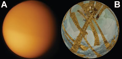
Here is a comparison between Voyager (A) and Cassini (B) images of Titan. The Voyager image only observed an opaque orange atmosphere of hydrocarbon haze. The Cassini image inlcudes high resolution SAR images overlain on top of low resolution infrared mosaics from the ISS and VIMS instruments
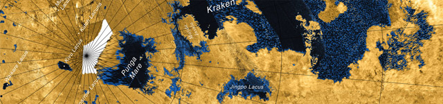
The RADAR discovered evidence for liquid hydrocarbon lakes in Titan’s north polar region during a flyby in July 2006. This discovery was published in an article, led by Dr. Ellen Stofan, submitted to the journal Nature in fall 2006. My involvement in Titan research began when the RADAR Team leader and Director of Jet Propulsion Laboratory, Dr. Charles Elachi, visited Caltech and unrolled a twenty foot long by two foot wide print out of the July 2006 radar swath down the hall outside my office. Between September 2006 and April 2007 the radar obtained an additional five images of Titan’s north polar region, covering more than half of the area poleward of 60°N.
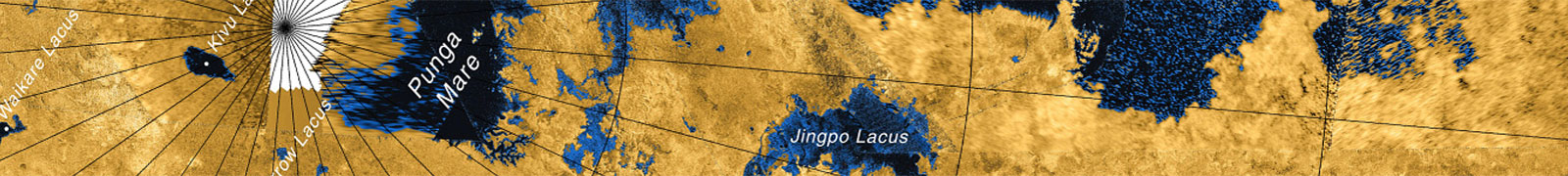
For the next several months we mapped hundreds of lakes found in the radar data and discovered evidence for multiple classes which spanned the range of observed morphologies on Earth (Figure 2 below). Polygonal lakes with complex shorelines and associated channels were similar to terrestrial drainage lakes you might expect to see in Northern Minnesota. Lakes with comparatively smooth and distinct shorelines and no associated channels were consistent with seepage lakes interacting with a local groundwater system, like you might see in the Everglades region of Florida. The largest lakes were found to be similar in size to the Great Lakes. When coupled with observations of longitudinal dunes near the equator, Titan was turning out to be a strange, yet familiar, place whose surface was dominated by the same geological processes we see here on Earth, even though the material and thermal conditions are vastly different.
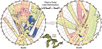
Pictured above is the distribution of lakes on Titan poleward of 60°. Filled lakes are blue and cyan while empty lakes are red. Background color corresponds to incidence angle during data acquisition. Note the outline of the Earth’s Great Lakes for scale. Areas where changes have been observed are outlined in magenta. More information on the lake distribution can be found in a 2008 publication in Geophysical Research Letters.
While we had a good picture of the north by spring 2007, there was very little radar data available in the south. I remember animated discussions, throughout 2007, regarding predictions for the density of lakes in the south. In the end the south was found to contain fewer lakes, with liquid covering a total surface area twenty-five times smaller than in the north. However, the reasons for this asymmetric distribution were not those commonly predicted, as the effect was found unlikely to be seasonal. In a 2009 publication led by Professor Oded Aharonson in Nature Geosciences, we suggested that this dichotomy is a result of non-symmetric seasons inherent to Titan’s orbit.
The peak solar flux in the south is about twenty-five percent greater than that in the north. The difference arises from the fact that Saturn, with Titan along for the ride, has an eccentric orbit. It so happens that southern summer, which occurs when Titan’s southern hemisphere is tilted towards the sun, coincides with perihelion, when Saturn is closest to the sun in its orbit. The more intense sunlight of southern summer results in a net flux of methane from the south to the north over many seasonal cycles, potentially resulting in the observed lake dichotomy. An interesting implication of this explanation is that it must change over time, as the orbital parameters which create the situation are slowly evolving. This scenario is analogous to Milankovich Cycles, which are credited with causing periodic climate change on Earth.
Above is an animation which illustrates the variations in Titan’s orbital parameters. In this depicted reference frame the orientation of Saturn’s orbit is help fixed and we see how the position of Titan’s seasons move with respect to perihelion and aphelion. At the present epoch perihelion coincides with southern summer solstice (northern winter solstice) and the there is a twenty-five percent difference in peak solar insulation between southern and northern summer. Thirty-two thousand years ago, however, the situation was reversed and northern summer was more intense.
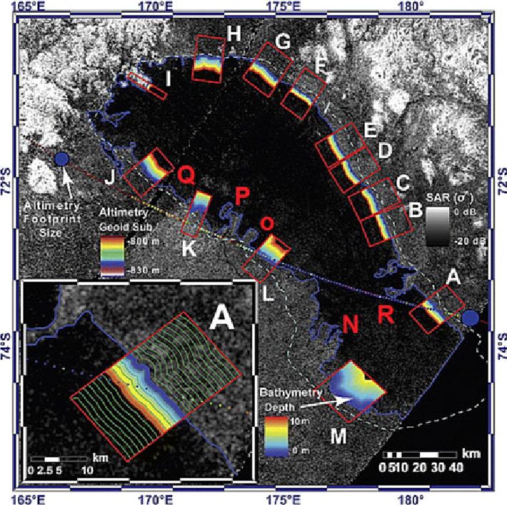
Above is an image of Ontario Lacus showing the near-shore bathymetry derived in the 2010 paper in JGR Planets. The bathymetry values are obtained by comparing the exponential decay of backscatter with distance from the shore around the lake and referencing to altimetry data obtained in Decemer 2008. The lake border as observed in 2005 is also shown. The magnitude of shoreline recession was shown to be linearly related to bathymetric slope and suggests the lake had an average loss rate of one meter per year between 2005 and 2009.
While studying the distribution of Titan’s lakes gave us a greater understanding of Titan’s hydrologic system, we still had no idea how they varied seasonally. This changed in the summer of 2009, when RADAR obtained is first images of Ontario Lacus. Ontario Lacus, Titan’s largest southern lake, was originally observed by the ISS instrument in 2004 and 2005. It was also observed by the VIMS instrument in late 2007, which was able to identify liquid ethane in its composition. In the RADAR images, Ontario Lacus looked smaller than it did in 2005. This was confirmed by lower resolution ISS images from March 2009. By combining the RADAR images with altimetry data obtained the previous December, we were able to show that places along the shore with the most shoreline recession corresponded to the shallowest section of the lake and that, in general, shoreline recession followed relative changes in near-shore slope. This is exactly what you would expect if the lake level dropped by a constant amount. Around the same time we were analyzing Ontario, we were also investigating smaller southern lakes which disappeared between flybys in 2007 and 2008/2009. By using the Ontario data to calibrate the RADAR’s absorption through the liquid, we were able to derive average loss rates for both Ontario and the small lakes of one meter per year. These results were very exciting because we were not only able to confirm the presence of an active hydrologic cycle; we were able to see it in action! A summary of these investigations was published in a pair of papers to the journals Icarus and JGR Planets in 2010 and represent the first direct evidence for surface liquid playing an active role in Titan’s hydrologic system.
The Cassini mission is now in its second extended mission, with Titan flybys planned out to 2017. Until recently, the RADAR held a monopoly on Titan’s north pole as higher latitudes were in darkness during northern winter. As the north moves into spring and sunlight begins shining again, Cassini’s passive imaging instruments will begin to observe the north polar lake district. We can look forward to a set of exciting new discoveries over the next few years as VIMS and ISS provide spectral information on the lakes and RADAR obtains repeat observations over many years, showing us how the system evolves. I am honored to be a part of this exciting time in Titan science and look forward to continuing to work with diverse and highly talented scientists on the Cassini RADAR Team.